Tag Archives: water

2.5M Homes to Be Threatened by Tidal Flooding by the Year 2100

Photo by Maureen Drennan 

Rising sea levels and climate change are putting a significant number of homes at risk of tidal flooding, according to a report released Monday by the Union of Concerned Scientists. The report warns that up to 311,000 coastal homes and about 14,000 commercial properties will be at risk of chronic flooding within the next 30 years. By the end of the century, the UCS says that number will increase to 2.4 million homes—valued at about $912 billion—and 107,000 commercial properties—valued at $152 billion.

The UCS’s study used three sea level rise scenarios to determine how many residential and commercial properties along the entire coastline of the lower 48 are at risk of becoming chronically inundated by high tides (which they defined as flooding an average of 26 times per year or more). The scenarios were in the absence of any major storm.

The state with the most homes at risk by the end of the century was Florida, with about 1 million homes—or more than 10 percent of the state’s current residential properties. New Jersey follows with 250,000 homes at risk, followed by New York with 143,000 homes at risk. These three states were also identified as thse that stand to lose the most in home property values by year 2100: Florida risks $351 billion, New Jersey may lose $108 billion, and New York nearly $100 billion, according to the analysis.

“Not all affected communities will share the same experience,” says Erika Spanger-Siegfried, senior analyst in the Climate and Energy Program at the UCS and a report coauthor. “Some may see sharp adjustments to their housing market in the not-too-distant future; some could see a slow, steady decline in home values; and others could potentially invest in protective measures to keep impacts at bay for a few more decades. In any case, by knowing how much time they have before a significant number of properties will be regularly flooded, communities can start planning and implementing responses now, while they still have a range of options from which to choose.”

Source: 

U.S. Coastal Property at Risk From rising Seas,” Union of Concerned Scientists (June 18, 2018)

Contact us for all your real estate needs.

Error: Contact form not found.

.

NID Adopts Drought Plan; Calls for 20% Conservation

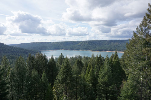
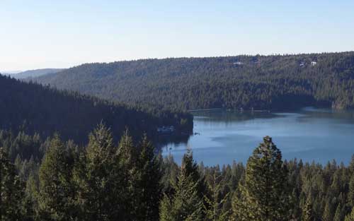
Looking over Scott's Flat Reservoir Picture taken from my deck John J. O'Dell
Looking over Scott’s Flat Reservoir Picture taken from my deck John J. O’Dell

March 25, 2015

Directors of the Nevada Irrigation District on Wednesday (Mar. 25) adopted a series of drought measures that include limits on outdoor watering and a call for continued 20 percent reductions in water use by all district customers.

In a presentation to the NID Board of Directors, Water Operations Manager Chip Close recommended a package of conservation measures designed to meet requirements adopted Mar. 17 by the State Water Board and to ensure that NID has adequate carryover water storage going into next year in case the drought continues into a fifth year.

Urban Water Use

Drought measures in effect for users of piped, treated water include:

  • Outdoor watering no more than three days per week, with no watering during the heat of the day (10 a.m. to 6 p.m.).
  • No watering until 48 hours after a rain.
  • No drinking water service in restaurants unless requested.
  • Hotel and motel guest option of not having towels and linens changed daily.
  • No water use that creates unnecessary runoff.
  • Use of shutoff nozzle on hoses.
  • No washing down of sidewalks
  • Fountains must recycle water

NID and other water purveyors are being required to provide the State Water Board with monthly reports on water use, conservation compliance and enforcement efforts.

Irrigation Water Use

Drought measures in effect for users of canal water include:

  • Voluntary reductions of 20 percent or more with mandatory reductions possible later in the year if conservation goals are not being met.
  • New and increased irrigation water sales are limited to the smallest amount of water necessary for the customer’s beneficial use.
  • All customers are encouraged to use efficient irrigation practices.
  • The irrigation season, which normally runs Apr. 15-Oct. 14, could be shortened this year depending on water availability.

In a water supply update, Water Resources Superintendent Sue Sindt said this year’s water outlook is slightly worse than last year.  She said the mountain snowpack is only about 6 percent of average water content for this time of year and that seasonal runoff is anticipated to be only 20-25 percent of average.

Officials credited district customers with reducing water use by an overall 16.4 percent during the 2014 drought and said an equal level or more will be needed to get through this year.

Close said that continued conservation, tight measurement and controls on the canal system, and the purchase of an available 20,000-25,000 acre-feet of additional water from the Pacific Gas and Electric Company will help meet the district’s water supply needs for this year and next.

For drought information and helpful water efficiency advice, please see NID’s website atwww.nidwater.com.  Water waste may be reported through an online form or by telephone, (530) 271-6799.


Help keep this blog going
Call or write today for all your
real estate needs

John J. O’Dell Realtor® GRI
O’Dell Realty
(530) 263-1091
EMail John O’Dell
BRE#00669941

Error: Contact form not found.

Nevada Irrigation Districts Lakes and Canals have Unusal Titles

Scotts  Flat Reservoir. Picture taken from my deck. John J. O'Dell
Scotts Flat Reservoir. Picture taken from my deck. John J. O’Dell

How’s the water out there in Wiskey Diggins Canal? Was the Fiddler Green Canal titled after an early day musician? Did you ever wonder how the DSL Canal was named?

The names of water storage and distribution facilities throughout NID are colorful and unusual but, unfortunately, the origination of many of them has been lost through the years.

Many facilities are named for builders, such as Faucherie Reservoir, or for the geographic areas they serve, such as Bald Hill or Pet Hill canals.

Of course, many lakes and canals carry names that are rooted in the area’s rich mining history.

The DS Canal is the lowest elevation of the two NID canals crossed by Red Dog and Banner Lava Cap roads near Nevada City. It was built by NID in 1927-28 to carry water from Lower Scotts Flat into the Nevada City-Grass Valley area.  The DS Canal follows the south side of Deer Creek, hence DS for Deer Creek South. If NID had followed through with an initial plan for a canal on the north side, we would today have the DN Canal.

How Scott Flat was named is unclear, but it is widely understood that it was due to the Scottish miners who lived and worked there in the 1850’s and 1860’s.  Schools once stood near what is now the campground on the north side of the lake.

Rollins Reservoir was named for J.L. Rollins, manager of the Bear River Water and Power Co., the company from which NID acquired the land to build the reservoir.

NID’s first modern water treatment plan, the Elizabeth L. George plant on Banner Mountain, opened in 1969 and was named after the long time community leader who helped gain funding for its construction.

In the high country, Faucherie Reservoir, built prior to 1880, was named after a French engineer who worked for the Eureka Lake & Yuba Canal Co.  “The French must have had a strong influence because French Lake, located upstream of Faucherie and constructed in 1857-59 was originally called Eureka Lake and later changed to French Lake,” wrote NID retiree Terry Mayfield who documented much of the district’ history during his 34 years with the district.

One of NID’s most historic canals is reputed to be the first mining canal in the state.  The Rough & Ready Canal was begun in 1850 as the first effort to build a large-scale mining ditch in California.

According to the Thompson & West History of Nevada County, “a man named Moore commenced to dig one from Deer Creek above Nevada City to Rough and Ready. The magnitude of the undertaking astounded the miners and they thought Moore was a lunatic, but he persevered until he had completed one mile, and then abandoned the enterprise.”

Moore’s project was taken over by a company in 1851 and by 1854 the canal to Rough & Ready was complete. NID took over the canal in 1925 as part of a water system acquired from the old Excelsior Water & Power Co.  Portions of the 13-mile-long Rough and Ready & Ready Canal remain in use today.

Source: Nevada Irrigation District newsletter Volume 35 Number 4 Winter 2014/2015

Help keep this blog going
Call or write today for all your
real estate needs

John J. O’Dell Realtor® GRI
O’Dell Realty
(530) 263-1091

Error: Contact form not found.


BRE#00669941

The Crocodile Man and the famous Crocodile Poncho

httpv://youtu.be/I7fZZUfvx0s

Rather than trying to tame wild stallions, fearless Costa Rican fisherman Chito prefers a playful wrestle in the water with his best pal Pocho – a deadly 17ft crocodile. The 52-year-old daredevil draws gasps of amazement from onlookers by wading chest-deep into the water, then whistling for his 980lb buddy – and giving him an affectionate hug. Crazy Chito says: “Poncho is my best friend. This is a very dangerous routine but we have a good relationship. He will look me in the eye and not attack me. It is too dangerous for anyone else to come in the water. It is only ever the two of us.”

Chito made friends with the croc after finding him with a gunshot wound on the banks of the Central American state’s Parismina river 20 years ago. He had been shot in the left eye by a cattle farmer and was close to death. But Chito enlisted the help of several pals to load the massive reptile into his boat. He says: “When I found Poncho in the river he was dying, so I brought him into my house. He was very skinny, weighing only around 150lb I gave him chicken and fish and medicine for six months to help him recover. I stayed by Poncho’s side while he was ill, sleeping next to him at night. I just wanted him to feel that somebody loved him, that not all humans are bad. It meant a lot of sacrifice. I had to be there every day. I love all animals – especially ones that have suffered.”

It took years before Chito felt that Poncho had bonded with him enough to get closer to the animal. He says: “After a decade I started to work with him. At first it was slow, slow. I played with him a bit, slowly doing more. Then I found out that when I called his name he would come over to me.”

Read more
Please help to keep this blog going
Let us Sell or help you buy your new home or land

John J. O’Dell Realtor® GRI
O’Dell Realty
(530) 263-1091
Email John

BRE#00669941

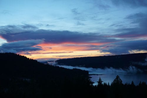
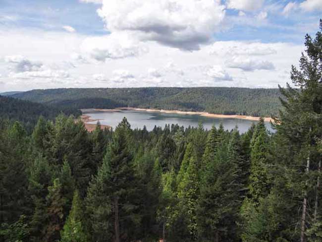
Scotts Flat Reservoir Lake Level September 2014

Scotts Flat Reservoir

Scotts Flat Reservoir
Picture 1 of 9

Scotts Flat Reservoir


Pictures  by John J. O’Dell from my deck.

The water level in the lake is down further than I’ve seen since I’ve lived in Cascade Shores, or at least it seems that way.  Scotts Flat Lake or should I say reservoir, what’s the difference?  A lake is a body of water but a  reservoir is different because it’s level is deepest at the dam and some other technicalities . Oh, well, I still like to call it a lake.  If you really want to know the difference between a lake and reservoir go to Lakes & Reservoirs.

If you want to see the projected water level for Scotts Flat Reservoir  that was prepared by Nevada Irrigation District, go to picture 5.  I’m guessing from my pictures and the graph for water levels for Scotts Flat Lake that the present elevation is around 3,036 foot elevation. The high appears to be 3,062  feet in elevation.  That’s a 26 foot drop which cuts the water storage in half, from 40,000 acre feet to 25,000 acre feet. An acre foot is one foot of water over one acre of land or 43,560 cubic feet of water.

Scott’s Flat is situated among the tall pines at the 3100-foot elevation nine miles east of Nevada City via Highway 20 and Scott’s Flat Road. It offers 169 campsites at two large campgrounds, plus a group camp. Across the lake, accessible via Red Dog and Quaker Hill Roads from Nevada City, is the Cascade Shores Day Use Area. As you can see from my pictures, there a lot of trees around the reservoirs, oops lake.

Please help to keep this blog going
Let us Sell or help you buy your new home or land

John J. O’Dell Realtor® GRI
O’Dell Realty
(530) 263-1091
Email John

BRE#00669941

Vernazza – the History, the Disaster and the Recovery Part 2

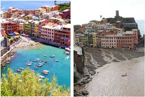
vernazza-before-and-after-f

Before and after photos.

The Disaster:

On October 25, 2011, Vernazza was struck by torrential rains, massive flooding and mudslides that left the town buried in many meters of mud and debris, causing over 100 million euro worth of damage. Three long time residents were killed in the flooding and mudslides that occurred on October 25, 2011, their bodies were found on the shore near St. Tropez, France.

People caught in the lower levels of the town had to flee upward in apartment buildings and private houses to get away from the torrential mud and water, gas leaks also broke out in the town, making people fear from the chance of fire as well as drowning. To read many other heartbreaking and heartwarming stories by residents and tourists caught in Vernazza on that day go to: Save Vernazza

On October 26, the tourists and townspeople were forced to walk through Vernazza at the height of the second story windows, over 4 meters/13+ feet of mud and debris to be evacuated by sea. The town was in a state of emergency, although repair work began immediately.

December 3, 2011: This day’s posting on the Save Vernazza Website reads:

“The only thing ‘normal’ in Vernazza these days is the train schedule. She is a town without her people… Imagine Vernazza without a single soul in it. If she were a person I’d say she’s lonely. Feeling abandoned. And I often think of her this way. Like a living being she has a life, a soul, a vibrance, a presence like no other place I’ve been. I find myself feeling sorry for her a lot of the time. Is this strange? Somehow I don’t think I’m alone in my feelings.”

December 2012: On the day after the flood, Mayor Resasco promised that the whole town would celebrate the Feast of the Immaculate Conception in Vernazza. On the morning of December 8, with the “asado” barbeque slowly cooking over the coals in Piazza Marconi, the trains arrived from La Spezia and Levanto, filled with families, elderly couples and children. The elderly, many of whom had never previously lived anywhere else, walked around with tear-filled eyes, marveling at how much had been accomplished in such a short time and mourning what had been lost. The volunteers were filled with pride at their role in giving so much joy to this community. The day was filled with friendship, hugging, laughter, tears and sharing stories. Talk of hope filled the air, as people began to envision a renewed Vernazza.

Tomorrow: The Rebuilding

Article by Judy J. Pinegar – Published in Corriere della Valle

Please help to keep this blog going
Let us Sell or help you buy your new home or land

John J. O’Dell Realtor® GRI
O’Dell Realty
(530) 263-1091
Email John

DRE#00669941

Enhanced by Zemanta

Water Wars In The Delta Continues

Photo credit: Bill Wells

By Burt Wilson
bwilson5404@sbcglobal.net

The Public Policy Institute of California (PPIC) event at the Sheraton last Friday was a signal to all the water agencies and their hangers-on that the PPIC wants to be a player in the California water war. If you will remember, the first PPIC report on the Delta a few years ago proposed an honest-to-goodness Peripheral Canal and a possible water barrier across the estuary at Chipps Island. Of course, we all know the Bechtal Corp., whose foundation funds PPIC, builds things like Peripheral Canals.

The event, in two words, was a “stacked deck.” Not one voice of opposition was seated on the stage. Only the usual cast of characters. The “environmental” voices were all party-liners, too. All did their thing and none bit the hand that pays them although Dr. Peter Goodwin, the head of the Delta Independent Science Board, speaking to the concept of Adaptive Management, did allow that, “There is so much uncertainty ahead of us that we have to have Adaptive Management.”
Almost every other word he used was “uncertainty.” I like this guy!

When he came off the stage, I met him with the statement, “Peter, if you want to stop uncertainty, just leave more water in the Delta and forget the tunnels.” He smiled and Jeff Kightlinger of the MWD, who was standing next to him, made a quick exit.

I got a chance to speak in a public comment period after the next group. I wanted to take issue with a couple of things Phil Isenberg, the Delta Stewardship Council chairman, said during his presentation. Phil began by philosophizing, saying, “The American People like to have a choice.” I told Phil, “That may be correct in the other 49 states, but not in California. We can’t vote on the twin tunnels of the BDCP plan. Jerry Brown is afraid he’ll lose. So we have no choice.”

I noticed that they did not give me the mic, but kept a firm grip on it while I spoke and took it away from me when I finished so I couldn’t reply to Phil’s answer. I did anyway. Shouted it out.
The other statement I took issue with was when Phil said, “Water problems make environmental problems.” I hit him with the same thing I told Dr. Goodwin privately, “Why not just leave the water in the Delta and don’t divert so much anymore and we can solve both our water and environmental problems.” Phil, as usual when he is cornered, retreated into a very long Shakespearian-like soliloquy that had all the characteristics of a fog moving under the bridge into SF Bay and swallowing up the city. It’s effect is that pretty soon people even forget the question. I think I even did.

The gamin-like Ellen Hanak, the PPIC chairperson for the event, was a strong facilitator and generally kept things moving but I didn’t hear one thing that I hadn’t heard before. The people sitting with me were curious about why she would give us a free continental breakfast and decent lunch to listen to 15 people telling us what we already know. You don’t spend that kind of money unless you want something back for it. What she got was the top water agency guys whose egos love the spotlight inherent in such functions.

Although the PPIC line differs here and there from the water agencies’ party line–but not so much as to make real waves–one came away with the impression that Hanak just wants to be a player with a seat at the water table. We’ll see.

A couple of more free lunches ought to do it, I thought.

On the other hand, doesn’t the Bechtal Corp. build water tunnels, too?


For all your real estate needs
Email or call today:

John J. O’Dell Realtor® GRI
Civil Engineer
General Contractor
(530) 263-1091
Email jodell@nevadacounty.com

DRE#00669941

Enhanced by Zemanta

Nevada County to Have Normal Deliveries of Water For 2013

Scotts-5-2013-Jan

Scott’s Flat Reservoir  (picture by John J. O’Dell)

Nevada Irrigation District has maintained good levels of reservoir storage and is planning to make normal deliveries this year.

District reservoir levels rose in the near record rains of November and December but the normally wet months of January, February and March brought just eight inches of precipitation to NID mountain watershed.

Official April 1 snow surveys, usually the year’s best indicator of seasonal water supplies, showed just 17% of average water content in a thin mountain snowpack.

Seasonal precipitation at Bowman Reservoir (elevation 5,650 feet) stood at 52.62 inches as of April 10, which equals 87% of average.  Seasonal precipitation is measured from July 1 to June 30 on a yearly basis.

April 10 storage in NID’s 10 reservoirs stood at 233,277 acre-feet, which is 93% of capacity and 125% of average for that date.

“Although we’re starting out with well above average water storage, we are expecting below average runoff from the snowpack” said NID Water Operations Administrator Sue Sindt.  “This could impact the amount of storage we are able to carry over for 2014”

Sindt said NID will continue a conservative approach in water system operation and is encouraging district customers to eliminate water waste and use water efficiently.

To Contact NID Call (530) 273-6185 or (800) 222-4102

Source: Nevada Irrigation District.


For all your real estate needs
Email or call today:

John J. O’Dell Realtor® GRI
Civil Engineer
General Contractor
(530) 263-1091
Email jodell@nevadacounty.com

DRE#00669941

Enhanced by Zemanta

Nevada Irrigation District Water Lines Extended to Rattlesnake Road

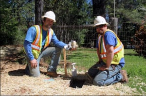
NID employees Chad Garvey, left, and Andrew Browning prepare to install a new water meter along Rattlesnake Road near Grass Valley

GRASS VALLEY  –  Treated water is now available in the Rattlesnake Road-Wheeler Cross Road area near Grass Valley, following a water line extension project completed this month by the Nevada Irrigation District.

NID and area property owners shared costs in extending a 16-inch main line from Dog Bar Road, across Wheeler Cross Road to the Rattlesnake Road intersection and 1000 feet north on Rattlesnake Road.

The job, with about 3000 feet of new pipe and three new fire hydrants, was completed for NID by C&D Contractors, Inc. of Nevada City.   New pavement overlay has been added throughout the project area.

Chip Close, NID’s interim water operations manager, said the project progressed rapidly through planning, design and construction after contracts were signed with participating property owners.  ”Our new customers were receiving water within nine months,” he said.  ”Our contractor was able to take advantage of the dry weather and good working conditions this winter.”

Officials said the new pipeline is part of the district’s master plan and can eventually be extended across Rattlesnake Road to existing pipelines near Highway 174, depending on public demand.

District maintenance crews are now installing new water meters at the 13 parcels that participated in the water line extension project.

Area residents with questions about NID water public water supplies may contact NID Business Coordinator Shannon Matteoni at (530) 273-618

For all your real estate needs
Email or call today:

John J. O’Dell Realtor® GRI
Civil Engineer
General Contractor
(530) 263-1091
Email jodell@nevadacounty.com

DRE#00669941

Enhanced by Zemanta

In Carlos Pelegrini and Esteros del Iberia, Argentina

httpv://youtu.be/pZ-jeqN0KCI

By Judy J. Pinegar

I had planned our stay at a Hospedaja (rooms behind a private house rented by the night) and I had taken one without meals because we were so used to having food ALL around in towns, but this was not a town in that sense… as you will see…

But the place was very nice, clean rooms with beautiful peaceful grounds and the lady suggested we sleep until later in the day, as it was so hot, and that was a welcome suggestion!  At 7 PM, with it beginning to be dusk, we struck out for what looked like, on the map, several restaurants, a few blocks away. But as John has now repeated several times to my chagrin, “in this town each block is a mile” and, so it was, not to mention ALL the roads were dirt, sand actually, which at least did not raise much dust when motorcycles (mostly) drove by. So with the help of some local girls we found a restaurant after about 6 of these blocks. Very good food, and inexpensive too. Nobody else in the room the entire hour although we could see they were preparing for the 10 PM “rush”, But by then we were back in bed as the next morning we had requested a boat tour of the Estos del Ibera wetlands and lake with a 7 AM start.

For those who don’t know (and we didn’t either until this trip to Argentina, and we have been here four times!) Estos del Ibera is a huge nature preserve around several large lakes, marshes, and the associated wetlands, 800 square miles of protected wetlands. Here, about 80 inches of rain fall a year, and most of it is just expired by the plants of the wetlands, there is only one small river leaving the area. Within the protected area there are 60 lakes from three to nine feet deep. The lake we were on, Ibera, has TONS of floating islands of vegetative greenery which support a whole (endangered) ecosystem of plants, mammals, insects, birds (over 300 species), and reptiles; the town of Carlos Pelegrini is basically a peninsula, with a VERY high water table.

You can see John’s pictures for some of the creatures, although we did not see all that were in books on the subject as it was only a 2 1/2 hour trip. Some of our favorites were the Capybara, a mammal, and the largest known rodent in the world, which average 80 pounds when full grown! Also the Cayman, like an alligator, only smaller, of which there were tons in the wetlands and water (they eat mostly fish), and their numbers are high because after they are adults they have no natural predators.

A very common bird was the Southern Screamer (quite black with neck stripes and a little white), we also saw the White Headed Marsh Tyrant (the rest of her body is black) and her nest in a small bush, Egrets, Kingfishers and Cormorants.  I saw a Strange Tailed Tyrant  (see http://en.wikipedia.org/wiki/Strange-tailed_Tyrant) but John didn’t get a picture. We also saw a marsh deer but it was too far away for a picture (http://en.wikipedia.org/wiki/Marsh_deer). Anyway it was a wonderful experience  and I can see this area becoming great for tourist traffic once they put in a few roads and a transportation system.


View Larger Map

For all your real estate neeeds
Call or email:

John J. O’Dell Realtor® GRI
Civil Engineer
General Contractor
(530) 263-1091
Email jodell@nevadacounty.com

DRE# 00669941

Enhanced by Zemanta